Drone Surveying in Construction: Survey Your Building Site
In the world of construction, it’s vitally important to have accurate surveys of your building site. This allows you to plan and map out your project accurately, ensuring that everything goes as planned.
In the past, this was done with traditional survey methods like using a theodolite or Total Station. However, drone surveying in construction is becoming more and more popular due to the many advantages it offers.

Tell me the meaning of a drone survey?
Drone surveillance refers to drone use to record aerial data using low-cost sensors such as multispectral and RGB cameras. During a drone survey using RGB cameras, the ground has been photographed from different angles, each photo carrying the coordinate. From this information, the software provides the georeferences to orthomosaic data. Maps can also serve for extracting precise distance and volumetric data.
How do drones collect data?
Drone data collection is performed on Geographic Information Systems. These data were used for identification and mapping purposes. GIS is used to collect data and can use several other tools to collect data from drones and other vehicles. In previous years, aerial photography drones were only used for captures, not transmissions. I
What is an orthomosaic?
Orthomosaics are aerial images that have been georeferenced and rectified so that they can be used in mapping applications. In order to do this, each image must be accurately geotaggedwith its corresponding location on the ground. This is done by using GPS coordinates or ground control points (GCPs). Once the images have been rectified, they can be mosaicked together to create a map of the area.
How do drones make orthomosaics?
Drones use photogrammetry software to create a map from aerial photography data. This process involves taking multiple photos from different angles and stitching them together to create a single image. The drone’s onboard GPS system is used as a reference point when creating the map, which allows it to be accurately geo-referenced.

Is Drone Survey necessary?
Maybe you wonder how do drones differ from traditional techniques? This is an excellent option. The UAV’s have access to data on locations that are hidden from the humans. It isn’t necessary to use humans physically to access hazardous areas. These traditionally used techniques are nevertheless required to be planned before launching in an area.
Drone Survey Data
One of the main advantages of drone surveying in construction is that it’s much faster and cheaper than traditional survey methods. With a drone, you can quickly map out an entire site in just a few hours. This is because drones can fly over large areas very quickly, whereas manual surveys would take much longer to complete.
Another advantage of drone surveying is that it produces high-resolution data. This is important for construction projects, as you need to have accurate measurements of all the features on your site. With drone technology, you can get very detailed images of your site, which can be used to create drawings and models.
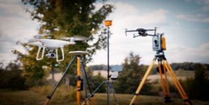
We fly our drones with very high overlap, both side as well as forward overlap of 80% which is very important for drone survey data accuracy. We use Ground control Points (GCP) to achieve absolute accuracy in our drone surveys. This is done by flying a drone over a known point on the ground and taking a photo of it.

Drone surveying in construction requires ground control points to achieve absolute accuracy, which are placed throughout the site before drone surveys take place. Ground Control Points (GCPs) are essential for drone surveying because they provide a reference point for the drone to calculate its position. By using GCPs, you can ensure that your survey data is accurate to within centimetres.
As with any new technology there are always skeptics when it comes to drone surveying in construction; but when you see the results that this tool can provide it’s hard not to be convinced. Accuracy is key
Highly detailed aerial maps can be produced with the help of drone technology and aerial survey software and techniques.
These maps can be used for a variety of purposes such as assessing progress on-site, planning and designing new projects, or checking building specifications.
The drone’s camera is also able to capture images and video footage which can be used as evidence in the case of an accident or dispute. This type of survey data can also help to identify any potential problems with a construction project early on, preventing costly mistakes further down the line.
Topographic surveys can be created quickly and easily with a drone,
Making it an ideal tool for use in large construction projects. The drone can fly over the entire site, capturing data which can then be used to create a detailed map of the area. This information is invaluable for planning purposes and helps to ensure that the project stays on track.
Drone Survey Mapping
Drones equipped with specialist survey mapping software can be used to create accurate maps of a construction site. These maps can provide valuable information such as the size and shape of the plot, the location of buildings and other structures on-site, and the height and angle of each element.
This data is essential for planning new projects or assessing progress on existing ones. The map can also be used as a base for creating other digital assets such as site plans, elevations, and section drawings.
The drone’s high-resolution camera allows for the creation of detailed maps with accuracy down to a few centimeters. This level of detail is essential for ensuring that all aspects of the construction project are accounted
In some cases, drone surveys may even be able to replace traditional land surveying methods altogether. With careful planning and execution, it’s possible to get all the information you need from a site using nothing more than a UAV and its attached sensors.

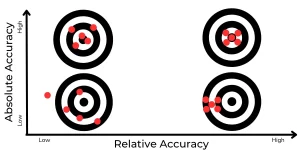
Drone Survey Accuracy
High relative accuracy is quite different to achieving high absolute accuracy. As drone surveying in construction becomes more popular, it’s important to realise that there are several factors which can affect the results of any survey or map produced by aerial drone data.
Relative Accuracy for Drone Surveys
This is determined by several factors including how high above the ground the drone is flown, camera sensor size camera lens focal length. Relative accuracy is accurate within the map itself, but not on the earths surface.
The drone’s position and altitude are all important aspects to consider when planning a drone survey – if the drone flies too low then it may not be able to see certain features on your site due to obstructions like trees or buildings; but if it goes too high up then some smaller details might also get lost among larger ones.

Absolute Accuracy for drone Surveys
To achieve higher levels of absolute accuracy, drone surveys need to be supported with ground control points. Ground Control Points are typically installed in the drone’s flight area and their position is determined using survey grade GPS equipment. By providing accurate horizontal coordinates within a drone map relative to these GCPs.
To achieve absolute accuracy
with a drone, ground control points (GCPs) are needed. These are physical markers that are placed on the ground at known locations, and their positions are then measured using RTK/PPK technology. The drone will be flown over these points during its mapping mission and can use them to check its own position as it flies, making sure that all data collected from the drone is accurate.***
The Importance of Absolute Accuracy in Surveying
Absolute accuracy is important when surveying sites that require centimetre precision. Construction projects are one such example; even small discrepancies in measurements can lead to building work being completed incorrectly.
High-rise buildings that require structural integrity and safety measures rely on drone surveys to ensure they are built exactly as the design specifies. The same applies to bridges, dams, tunnels and other large-scale infrastructure projects.
Roads are another important application for drone surveying with absolute accuracy
not only does it help ensure a smooth, safe surface for drivers and pedestrians, but drone surveys are also used to monitor construction progress.
With the use of drone surveying in construction, it is possible for site managers to see a birds-eye view of their project on a daily basis; this helps them stay up-to-date with how works are progressing against schedule.
Ground Control Points (GCP) for drone Surveys
In order to achieve absolute accuracy in drone surveying, ground control points are required. These are physical markers that are placed on the ground at known locations, and their positions are then measured using RTK/PPK technology.
The drone will be flown over these points during its mapping mission and can use them to check its own position as it flies; making sure all data collected from the drone is accurate
Traditional Methods vs Drone Surveys
The use of ground control points is not a new technique, but it is one that has been revolutionised by drone surveys. Until recently, the only way to achieve absolute accuracy in surveying was through the use of expensive survey equipment and teams of skilled technicians.
Now, with the advent of affordable drone technology and RTK/PPK drone accessories, drone surveyors can achieve absolute accuracy at a fraction of the cost.
Can drone surveying in construction be used without ground control points?
Some drone surveyors will suggest that drone surveys can be carried out without the need for ground control points, but this is not correct. The only way to achieve absolute accuracy in drone surveys is with GCPs. ption: drone surveying in construction can be used to create accurate surveys of your building site. using uav technology with rtk and ppk creates absolute accuracy. ground control points assist with this accuracy.
Can drone aerial surveys meet engineering standards?
The Drone Survey has a more pronounced use in building, development, mining, agriculture and other business activities.
Drone surveys can offer benefits that traditional methods cannot is the ability to map large areas quickly and efficiently. This makes them ideal for surveying construction sites, where changes are constantly happening and a fast turnaround is essential.
What kind of deliverables can you achieve with Drone Surveying?
Depending on Survey Software and Data Sensors, drones can deliver varying types of deliverables. A simple drone survey with a single camera can deliver orthomosaics, point clouds, digital surface models (DSMs) and textured meshes. more complex missions using multiple cameras or sensors can provide additional data products such as volumetric measurements and contours.
Conclusion
Drone surveying in construction is the answer to more accurate and efficient surveys of your building site. With drone technology and RTK/PPK positioning you can achieve accuracies within centimetres which saves time and money. Drone surveys are also faster and cheaper than traditional survey methods so contact us today to get started on your own project!