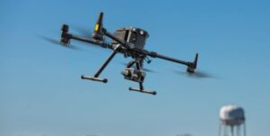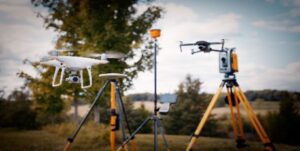
The DJI M300 RTK is a drone surveying powerhouse. When tasked with a particularly complex or large area it is important to have the correct tools to complete the job correctly. That’s where the M300 RTK doesn’t fall short.
With a maximum flight time of 55 minutes, the M300 RTK can easily cover large areas quickly and efficiently. But that’s not all, the M300 RTK is also equipped with an array of powerful sensors that make it perfect for surveying tasks.

The M300 is often paired with the H20T sensor. It’s a multi-sensor payload that’s both technical and versatile. However, the built-in 1-inch 20MP CMOS sensor with a mechanical shutter that the Phantom 4 RTK is actually better for surveying than the H20 or H20T. Both RGB cameras on the H20 series are underwhelming for photogrammetry, with the wide-angle camera having only 12 MP and not being particularly excellent at photogrammetric processing. Fortunately, based on what we’ve seen so far, the Zenmuse P1 appears to be a fantastic sensor for photogrammetry workflows, which has us very hopeful.
If you are conducting a drone survey in an area with large variations in terrain elevations and with particularly steep topography then using the Zenmuse P1 sensor is ideal when paired with a suitable flight planning app. Drone Harmony, DJI Pilot and UgCS allow terrain following in which the drone will increase and decrease altitude based on the elevation of the ground. This is determined by inputting a digital elevation model into the flight planner. Drone Harmony also has a feature which is an incredible for resource when drone surveying on a hill or cliff face in where the camera orientation is changed to match the gradient of the ground. This ensures a uniform overlap and optimal view of the ground at all times.
The wide array of sensors on the M300 RTK make it perfect for any surveying task you might come across. Photogrammetry is made easy with features on the P1 sensor such as smart oblique capture. This allows for the capture of high-resolution images at low altitudes and a variety of angles. You can capture an area very quickly to create a high resolution 3D model.
Another powerful sensor is the Livox Mid-100 LiDAR. This is an accurate laser scanner that can be used to map large areas with great detail and accuracy. It’s perfect for surveying tasks such as measuring volume, calculating cut and fill earthworks and mapping terrain features. This is compatible with the M300 as well as the Zenmuse L1 which is native to DJI.
The M300 RTK also supports thermal imaging with the Zenmuse H20T sensor. This is perfect for conducting surveys of solar panels or other heat emitting objects from a distance.
The shutter speed interval of 0.7sec allows the drone survey to be captured much more quickly than most other drones which might have a shutter interval of 2sec or more. The 45mp sensor also means you can fly higher and achieve the same ground sample distance as a 20mp at a much lower altitude.
Drone surveying has become more popular in recent years as the technology has become more accessible and advanced. The M300 RTK is a perfect example of how drones are being used to survey large areas quickly, efficiently and accurately.
The
- Large transmission distance: Visual image on the monitor of up to 15km away and supports triple-channel 1080p video
- Powerful Motors: Flies 83kmh with up to. 55min flight time
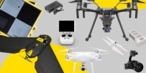
- An array of compatible sensors: LiDar, high megapixel RGB, thermal, zoom cameras. Up to 3 different payloads at one time
- Collision Avoidance: The most advanced collision avoidance in a DJI drone. The CSM radar also makes the M300 extremely safe even around powerlines at night.
- IP45 Rating: A high weather rating protects against objects >1.0 mm, and water projected in powerful jets (12.5 mm (0.49 in)) against the enclosure from any direction
Zenmuse P1 Sensor
The Zenmuse P1 features a 45 MP sensor and a global mechanical shutter. These characteristics are ideal for photogrammetry operations. The Phantom 4 RTK has a 20 MP sensor, which provides high-quality data. Although with the P1 and its 45mp sensor, you will be able to fly higher, save time gathering data in the field, and achieve 3cm vertical accuracy
Full-frame Camera
- 45 MP Sensor
- Global Mechanical Shutter
- 3-axis Stabilised Gimbal
Multiple Fixed-focus Lens Options
- 24mm, 35mm & 50mm
- the 35mm version of the lenses is the only one that is optimised correctly for accurate aerial surveying

Accurate Drone Surveying
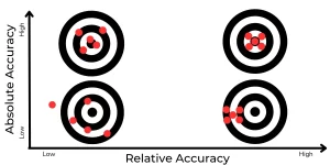
The M300 and P1 bundle can capture 250 acres in a single flight and obtain the same precise survey accuracy due to the faster drone speed, rapid shutter speed, and higher MP camera. So, how do the M300 and PPK work together? Here’s a brief rundown.
PPK requires a combined hardware and software solution for the most accurate results that includes high-precision ground control points. The software can be a photogrammetry processing solution such as Pix4D, Agisoft Metashape or Bentley Context Capture.
These three components work together to form a solution that is easily integrated into your current operation for highly accurate aerial surveyng. You’ll be able to collect more accurate data (including surveying difficult terrain or in bad weather) in less time and with fewer man hours, allowing you to focus on your business goals.
LiDAR Surveying with the L1
In the past, a good LiDAR setup would cost North of $170,000. But, the price for this LiDAR solution is very competitive at approx $20000-$25000 AUD.
In non-vegetated areas, the P1 will be superior to the L1. However, in regions with light to moderate vegetation, the L1 may shine. The most probable best workflow will combine photogrammetry and LiDAR data in order to obtain the best of both worlds, which is possible because the L1 has a 20mp global shutter camera which can be used simultaneously with the L1.

Contact High Exposure to discuss your drone surveying project at info@highexposure.com.au