Drone Roof & Facade Inspection – Australian National University Canberra
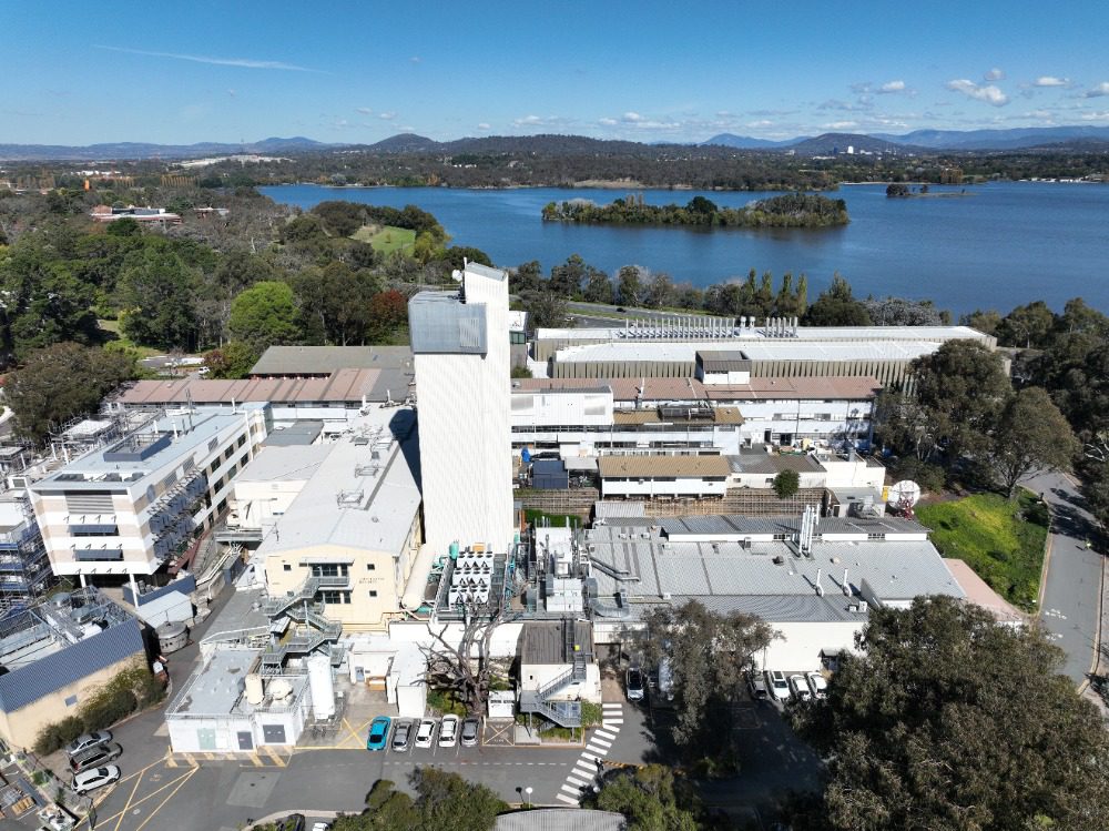
High Exposure was engaged by the main contractor overseeing the remedial repairs of Australian National University in Canberra to assist with assessing damages to a
Utilising various sensors, a drone is able to collect enormous amounts of accurate data of natural areas quickly and accurately. Laser scanning, photogrammetry, ground penetrating radar and various other scanners are capable of understanding the environment with incredible accuracy and resolution
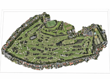
Mapping of an area can be undertaken quickly and efficiently to produce results with fast turnarounds. Highly accurate 2D and 3D mapping surveys are available with the capability for measurements to be recorded. This aids in land-use planning and environmental impact assessments.
High resolution models and dense colourised point coilds can be generated using LiDAR and photogrammetry processes. This provides a high level understanding of the terrain or vegetation
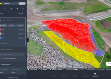
Elevation data is essential for many industries and the creation of contour maps provides detailed information for our clients. Our drones use advances photogrammetry software.
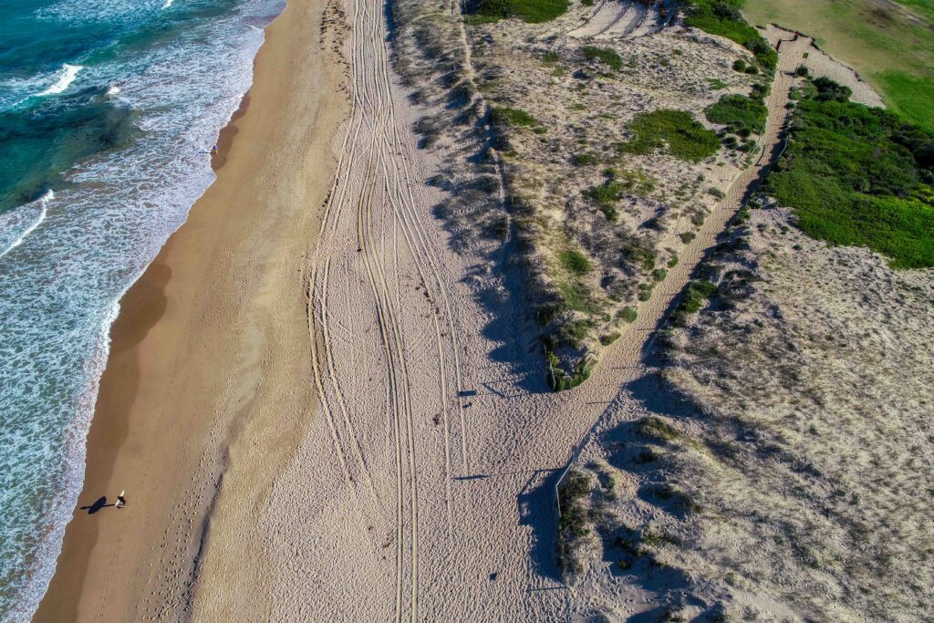
Using industry leading drone photogrammetry software Pix4D, we are able to accurately measure stockpile inventory on site. The process is very effective for monitoring changes in dunes and eroding river banks.
Hundreds of acres can be mapped quickly and accurately for general crop monitoring and farm planning using aerial NDVI sensors.
Thermal sensors are useful for identifying wildlife movements at night
Drones play a crucial role in assessing the aftermath of natural disasters such as hurricanes, earthquakes, or floods. They can quickly survey affected areas, identify damaged infrastructure, and help plan and coordinate disaster response efforts.
Drones equipped with LiDAR (Light Detection and Ranging) technology can penetrate dense forest canopies, providing detailed 3D maps of the terrain. This is crucial for assessing forest health, measuring tree biomass, and detecting signs of diseases or illegal logging activities.
drones assist in optimising resource use by providing detailed information on crop health, soil conditions, and irrigation needs. This precision helps farmers reduce input costs, minimize environmental impact, and enhance overall sustainability.
Drones are used for anti-poaching efforts, monitoring endangered species, and protecting wildlife habitats. Their discreet and non-intrusive nature allows researchers to observe wildlife behavior without causing disturbance.
Drones equipped with specialised instruments can collect atmospheric data, contributing to climate change research. This includes monitoring greenhouse gas emissions and studying change monitoring of areas
The use of drone imagery empowers scientists to evaluate alterations in riverbank vegetation, measure river heights, and observe bank erosion with enhanced precision. This technological advancement enables water managers to prevent bank damage and enhance the health of riverbank vegetation
Completing periodic aerial surveys enables a comprehensive analysis of environmental shifts. This innovative approach facilitates the ongoing monitoring of ecosystems, tracking alterations such as deforestation, land use changes, and other environmental transformations. The use of drones in aerial surveys enhances our ability to observe and understand changes in the natural world more efficiently and accurately.
Drones are useful for regulatory compliance in environmental monitoring and management. This requires capturing the data and analysing to determine if there are threats which may have an environmental impact
Drones can access difficult or dangerous terrain, such as dense forests, steep slopes, or areas with limited human accessibility. This makes it possible to collect data from locations that would be challenging for ground-based surveys
Drones can fly predefined routes with high precision, ensuring consistency in data collection during repeated surveys. This is important for tracking changes over time
Compared to traditional survey methods, drones have a smaller environmental footprint, as they do not require heavy machinery or ground vehicles to cover large areas
Drones can provide real-time data, enabling rapid response to environmental changes or emergencies. Real-time monitoring can be crucial for tracking dynamic environmental conditions, such as wildfires, flooding, or pollution events
Drones can be equipped with a variety of sensors, allowing for customization based on the specific needs of the environmental survey. This flexibility makes them adaptable to different types of studies
Drones equipped with high-resolution cameras and scanners that can capture detailed imagery of the environment. This is particularly useful for monitoring changes in land cover, vegetation health, and identifying specific features or anomalies
Drones are often more cost-effective than traditional survey methods, such as manned aircraft or ground-based surveys, especially for large or remote areas. They can cover large expanses of land in a relatively short amount of time, reducing overall survey costs.
There is no need to put a human in a dangerous position which eliminates any potential threat to injury
Using drones to capture data of the environment involves a systematic process that combines technology, planning, and data analysis.
Mission Planning: Define the objectives of the drone mission, including the specific data to be captured and the area to be surveyed. Consider factors such as flight altitude, camera specifications, and environmental conditions. Develop a flight plan that optimally covers the target area.
Drone Selection: Choose a drone with suitable features for the intended mission. Consider factors such as payload capacity, flight time, camera resolution, and sensors. The selection should align with the data capture requirements and environmental conditions.
Sensor and Payload Configuration: Install and configure sensors or cameras on the drone based on the data to be collected. Different sensors, such as RGB cameras, multispectral cameras, LiDAR, or thermal imaging, can be used depending on the specific goals of the environmental assessment.
Pre-flight Check: Conduct a thorough pre-flight check to ensure the drone is in optimal condition. Verify the functionality of all components, including batteries, GPS, and communication systems. Confirm that the payload is securely attached and calibrated.
Launch and Data Capture: Execute the planned flight path, ensuring that the drone covers the entire target area. Capture high-quality images, videos, or other relevant data during the flight. The drone’s GPS coordinates and altitude are typically recorded with each capture to geo-reference the data.
Data Storage and Transmission: Store captured data on the drone’s onboard storage or use real-time transmission to send data to a ground station. High-resolution images or sensor data may require substantial storage capacity, and planned accordingly.
Post-Processing: After the flight, process the captured data to deliver the information in a meaningful way that can give clarity to decisions being made. This may involve stitching images together, aligning data with ground control points for accuracy, and calibrating sensor data. Software tools such as photogrammetry or GIS applications are commonly used for post-processing.
Data Analysis: Analyse the processed data to extract meaningful information. This could involve identifying changes in land cover, measuring environmental parameters, or navigating 3D models. Data analysis tools and algorithms specific to the environmental objectives are applied in this phase.
Reporting and Visualisation: Present the analysed data in a comprehensible format. Generate reports, maps, or visualisations that convey the environmental information effectively. This step is crucial for decision-making and communication with stakeholders.
Iterative Process: Depending on the goals of the environmental study, the process may be iterative. Data capture may be repeated over time to monitor changes or cover different seasons, contributing to a more comprehensive understanding of the environment.
High Exposure was engaged by the main contractor overseeing the remedial repairs of Australian National University in Canberra to assist with assessing damages to a
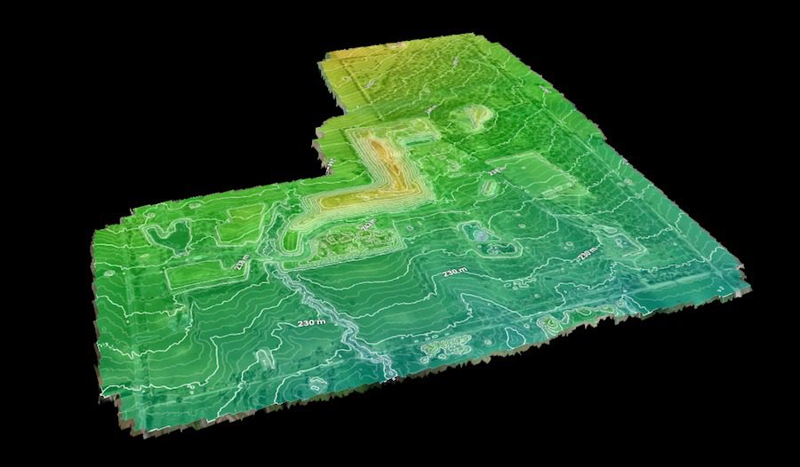
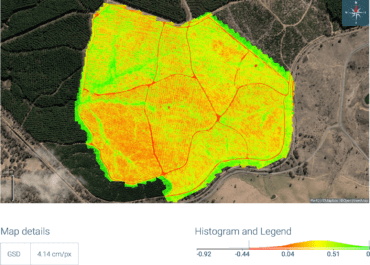
High Exposure Commercial Drone Services undertook an aerial survey at the 250-hectare Gregadoo Waste Management Facility, employing drone photogrammetry and LiDAR capture techniques. The primary
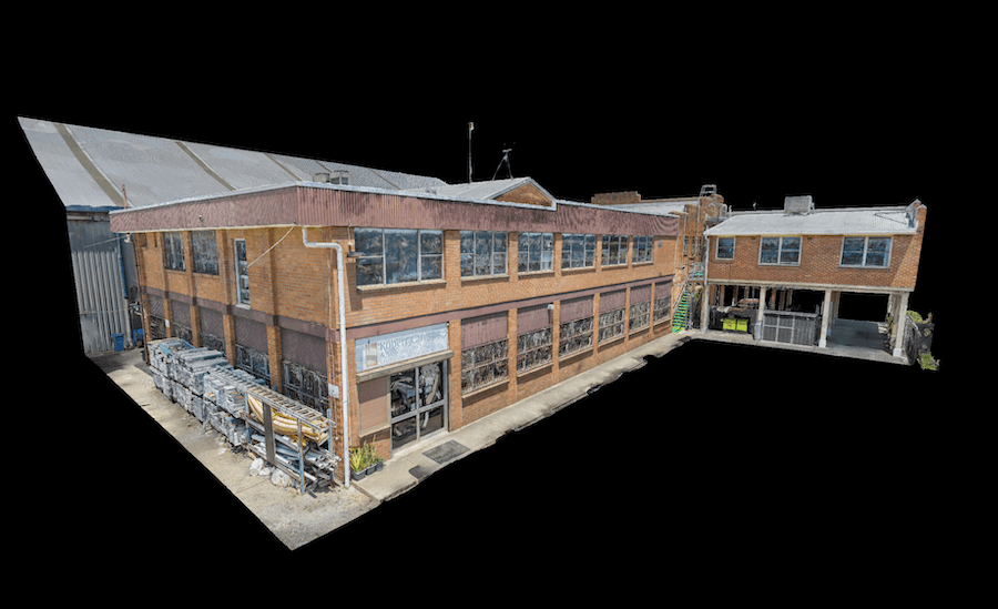
High Exposure was engaged to undertake a significant project to create a high-resolution aerial photogrammetry 3D model for a thorough inspection of brickwork on the