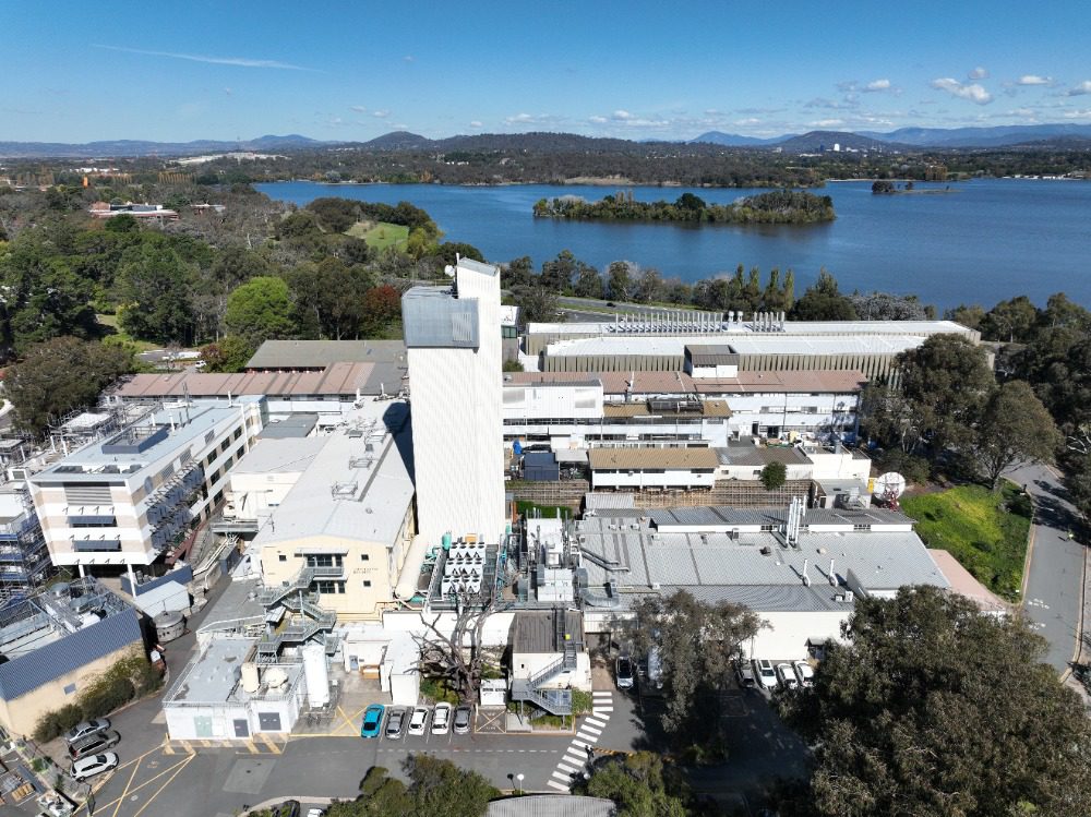
Drone Roof & Facade Inspection – Australian National University Canberra
High Exposure was engaged by the main contractor overseeing the remedial repairs of Australian National University in Canberra to assist with assessing damages to a
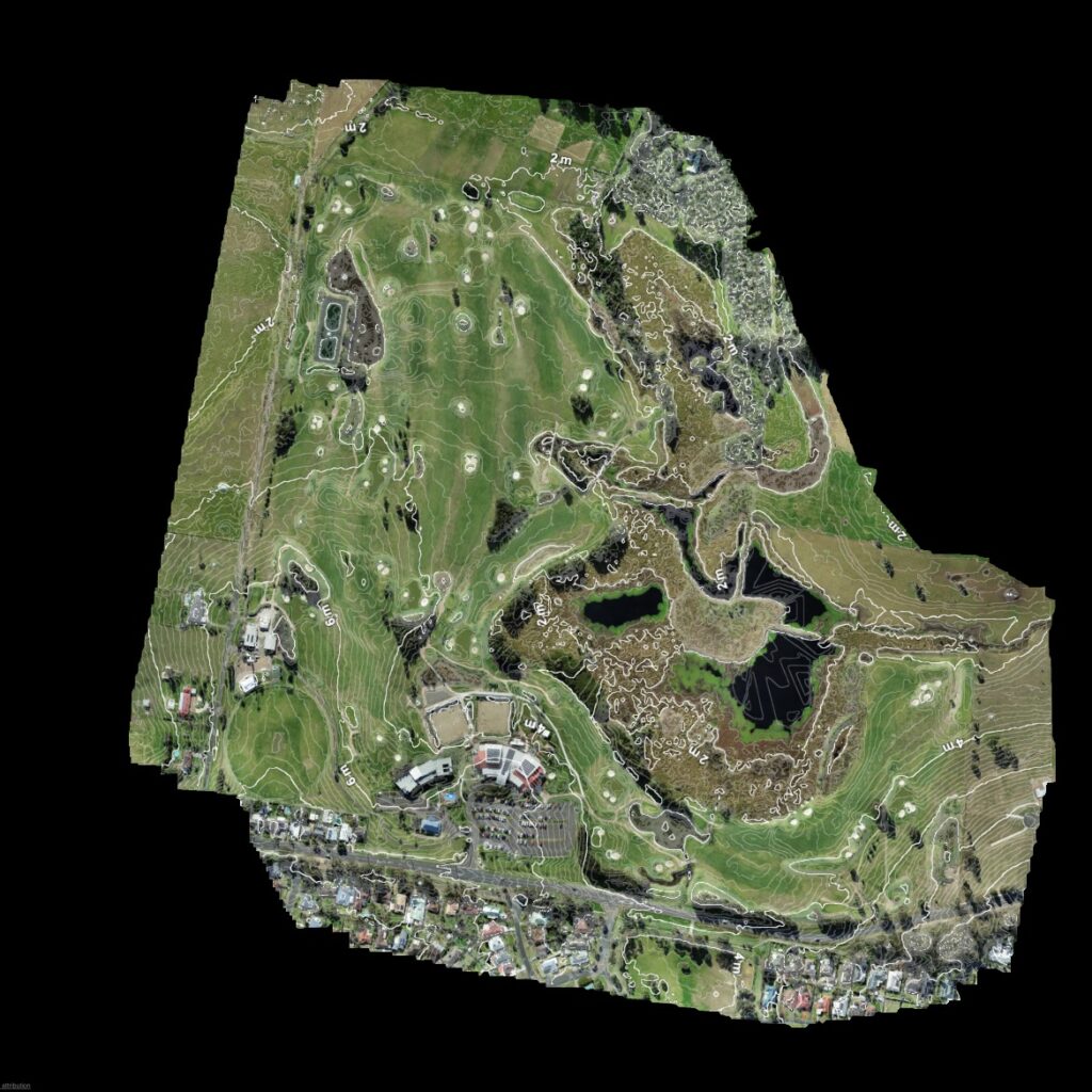
Aerial mapping using UAV’s provides a complete visual and data rich record of your work site or land area. A periodic mapping schedule allows site managers and stakeholders to monitor changes to ensure a project is being carried out to plan and on time. They assist greatly in ensuring a project is completed correctly, on time and on budget.
High Exposure has optimised a process from years of experience in the field capturing photogrammetry data to provide a deliverable that has proven to be so useful in the planning and decision making process throughout a projects life cycle that cost and time efficiencies have vastly improved.
Drone surveys can provide a variety of deliverables depending on the specific needs and goals of the project
Topographic Mapping:
Land Use Planning:
Environmental Monitoring:
Flood Risk Assessment:
Telecommunication Tower Placement:
Urban Planning:
Construction and Earthwork Projects:
Natural Resource Management:
3D Visualisation:
Drone survey capture with photogrammetry processing. These online visualisation software enables measurement capability reducing the need tfor boots on the ground using traditional methods of data capture
Jump on board with the forward thinking companies embracing new technology to obtain meaningful data more efficiently than ever
Rather than having surveyors on site in dangerous or hazardous areas, we can undertake the operation with zero risk to human life
Due to the lower cost of drone inspections, assets can be inspected more frequently and with higher volume of data is able to be captured minimising the chance of missing something. This leads to identification of dangerous terrain or structures early before they can become a hazard to people
Frequent general aerial surveys on construction sites can spot issues quickly to ensure the safety of people onsite
Often what takes days with traditional methods can take hours with drones using less people to conduct the survey.
The equipment used is cheaper than traditional methods and therefore cheaper to hire.
Manned inspections are often associated with enormous insurance costs which are greatly reduced.
Potential work cover claims are also reduced due to the safety of using drones for surveying and 3D Model mapping.
A drone can be set up within minutes of being on location and easily navigate around the asset.
No need to set up harnesses,ladders or organise a team to cover large areas.
Also no need to shutdown systems resulting in zero service downtime.
Using rope access , EWP’s or scaffolding has its limits. We can position aerial cameras in the ideal position to enable a high resolution survey of your site or asset.
This gives you a higher quality of data than what would ordinarily be available.
Being able to place drones in these areas so easily without human presence can prevent the need for service interruptions to assets
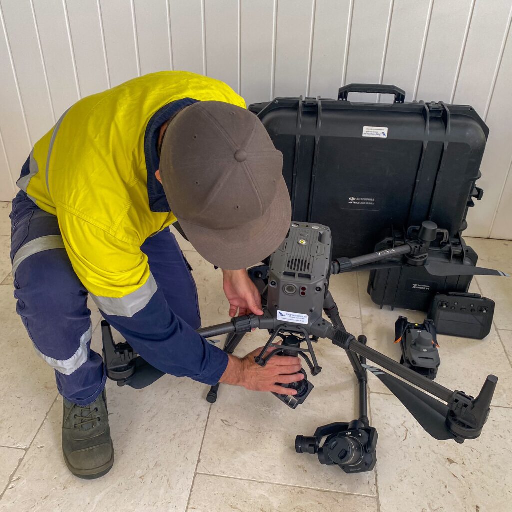
High Exposure employs a meticulous step-by-step process for drone survey data acquisition, processing, and visualisation to ensure optimal results and valuable insights for our clients.
Project Planning and Pre-flight Analysis: Before deploying drones, our team conducts thorough project planning, defining survey objectives, and assessing the specific requirements of the area to be surveyed. Pre-flight analysis involves evaluating airspace regulations, weather conditions, and potential obstacles.
Flight Mission Execution: Trained and certified drone pilots execute the flight mission, precisely navigating the drone to capture high-resolution images or videos of the survey area. Advanced sensors and cameras on the drone ensure accurate data collection.
Data Collection: During the flight, the drone collects georeferenced images or videos, capturing the desired data points. The drone’s ability to access hard-to-reach or hazardous areas enhances the comprehensiveness of the survey.
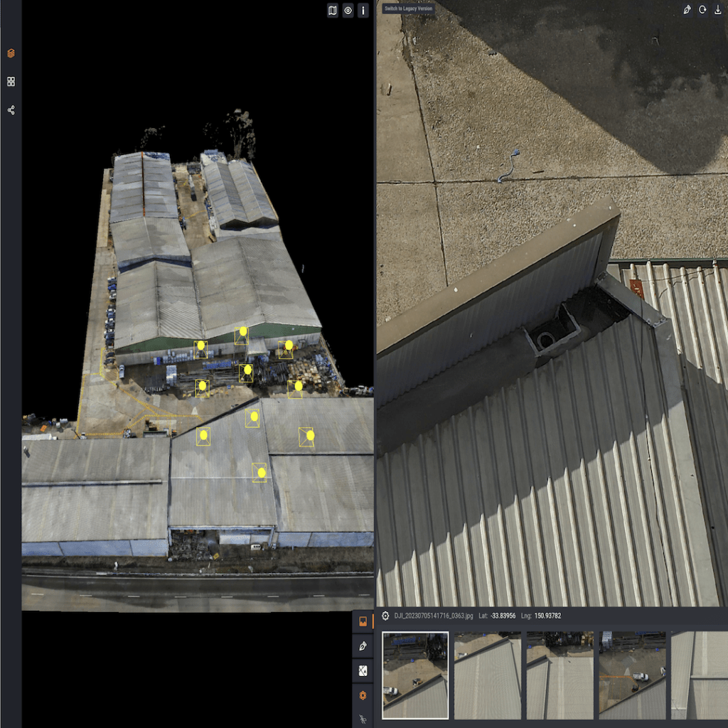
Data Processing and Stitching: Post-flight, acquired data undergoes meticulous processing. Image stitching and georeferencing techniques are applied to create seamless and accurate maps or 3D models. This step ensures the precision of the collected data.
Data Analysis: Processed data is subjected to in-depth analysis, extracting relevant information based on project requirements. This may include topographic features, volumetric measurements, or other specific parameters tailored to the client’s needs.
Integration with GIS (Geographic Information System): The survey data is integrated into GIS platforms, enhancing its spatial context and allowing for a more comprehensive understanding of the surveyed area. GIS integration facilitates effective decision-making by providing a geospatial perspective.
Visualisation and Reporting: High Exposure focuses on delivering insights in a user-friendly format. We create visualisations such as maps, 3D models, and interactive reports, ensuring that our clients can easily interpret and derive meaningful conclusions from the surveyed data.
Client Collaboration: We actively involve clients throughout the process, seeking feedback and adjusting our approach based on their evolving needs. Collaboration ensures that the final deliverables align with the project objectives and exceed client expectations.
By adhering to this meticulous process, High Exposure ensures that drone survey data is not only accurately acquired but also transformed into actionable insights, putting our client in the drivers seat with the information they need for informed decision-making. Project objectives have never been completed this quickly with such clarity on next steps.
High Exposure was engaged by the main contractor overseeing the remedial repairs of Australian National University in Canberra to assist with assessing damages to a
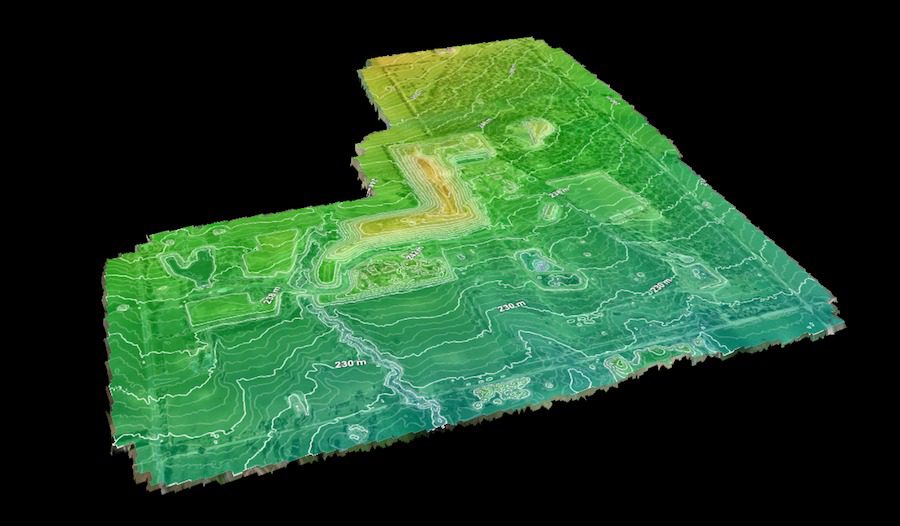
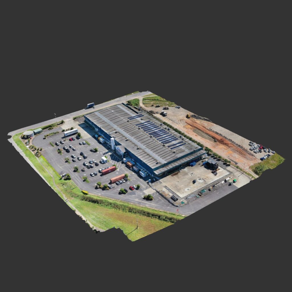
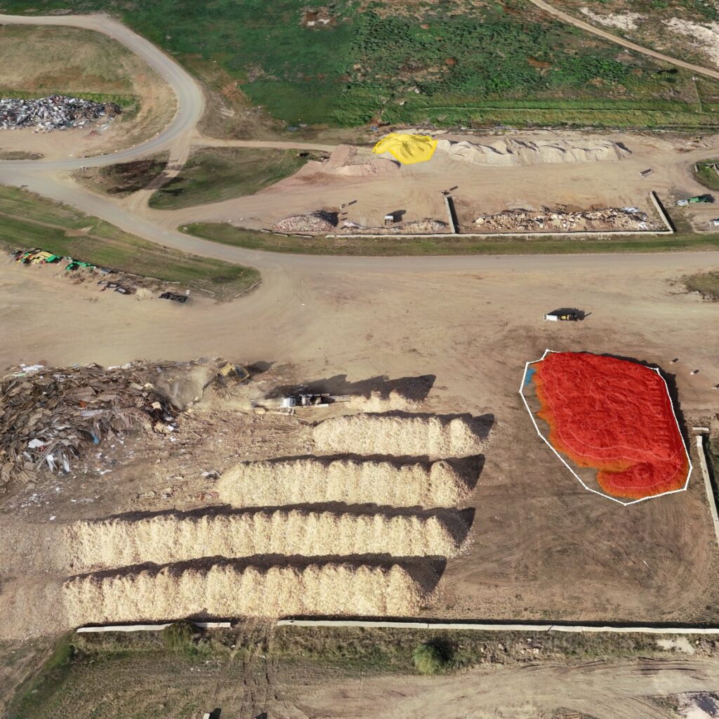
High Exposure Commercial Drone Services undertook an aerial survey at the 250-hectare Gregadoo Waste Management Facility, employing drone photogrammetry and LiDAR capture techniques. The primary
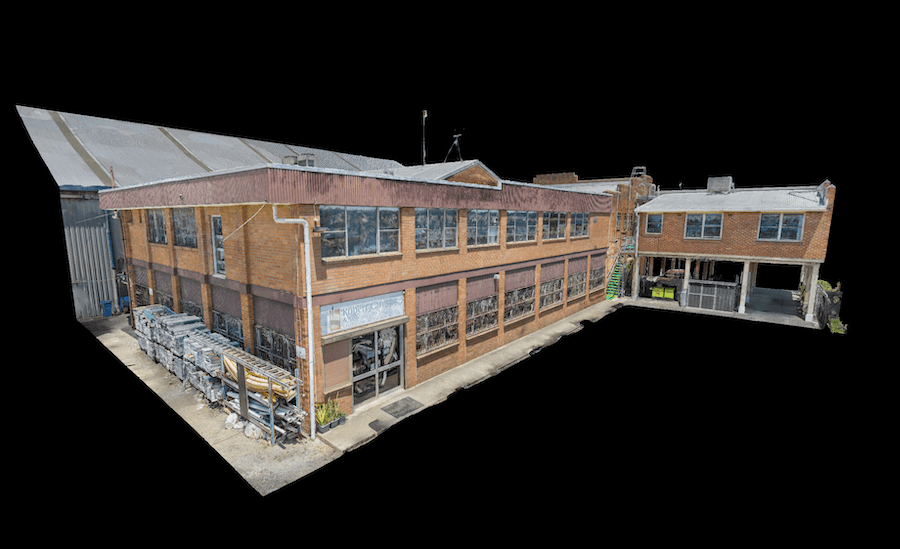
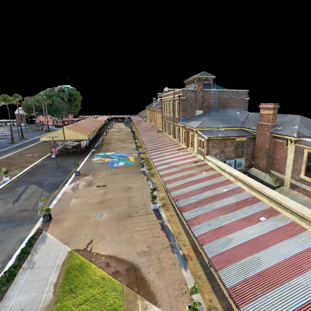
High Exposure was engaged to undertake a significant project to create a high-resolution aerial photogrammetry 3D model for a thorough inspection of brickwork on the
Lorem ipsum dolor sit amet, consectetur adipiscing elit. Ut elit tellus, luctus nec ullamcorper mattis, pulvinar dapibus leo.
We are able to capture useful data of almost anything. Existing projects have included, but not limited to building facades, rail infrastructure, water reservoirs, telecommunications infrastructure, bridges, and roof tops. Let our team know your ideas today and we will tailor a service to meet your needs.
We use high resolution cameras to ensure we are able to maintain a safe distance from the infrastructure and still produce high quality imagery.
We can provide a digital handover of the images & video via a web link which the client can download. Although, on request we are able to live stream the video online to clients if they need an immediate report. We also offer 3D modelling of infrastructure that has proven very useful for clients.