Drone Inspection & Digital Twin – Commercial Building

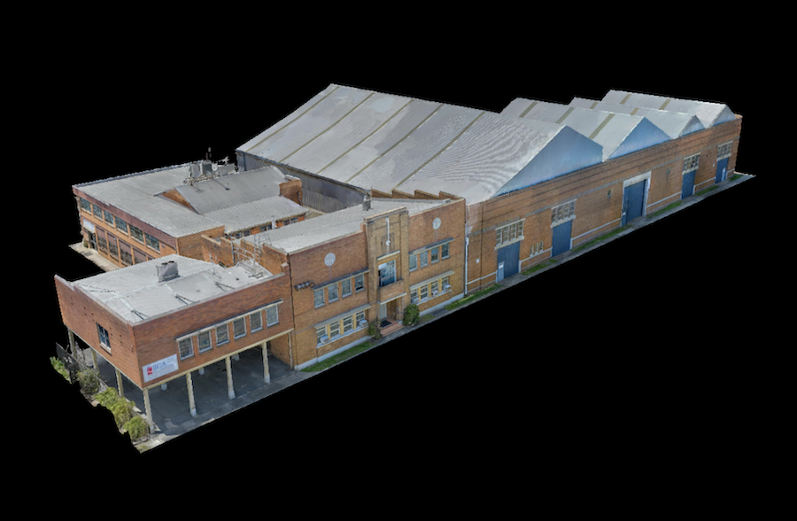
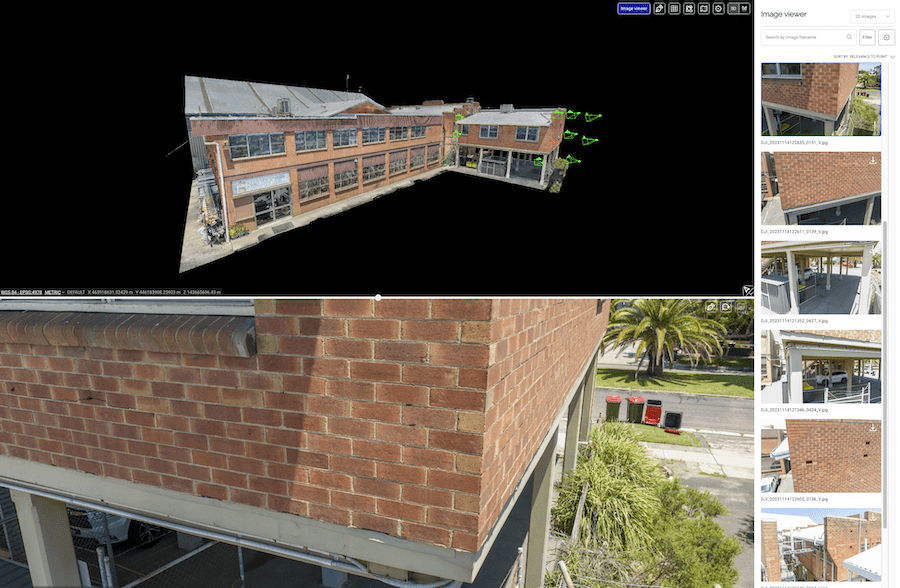
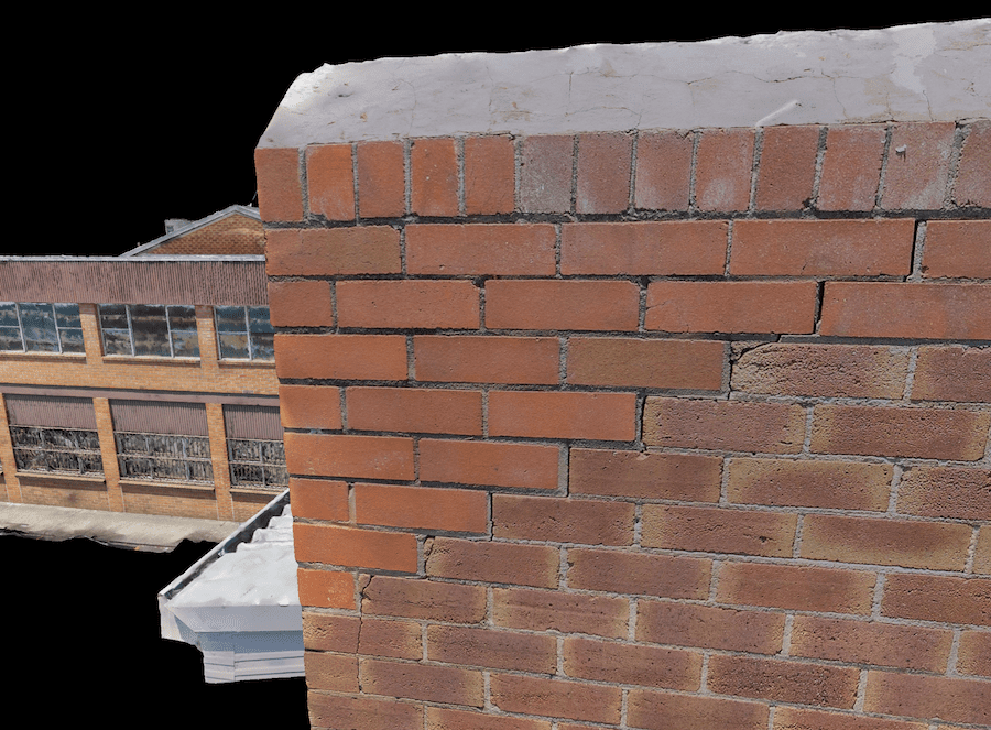
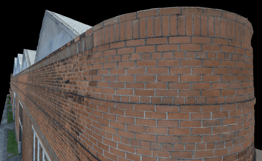
High Exposure was engaged to undertake a significant project to create a high-resolution aerial photogrammetry 3D model for a thorough inspection of brickwork on the facades and roof capping of a commercial premises. The objective was to leverage modern drone and photogrammetry technology to capture detailed imagery, enabling remote inspection for defect detection and facilitating the creation of a comprehensive dilapidation report. 
This deliverable eliminates any gaps in data, allowing full knowledge of the asset.
JPEG images can be viewed by clicking on any point in the model. This allows complete context and highest possible clarity of any area
  • Objective:

Capture high-resolution imagery of brickwork for detailed inspection and defect detection.

  • Methodology: Utilise an RTK (Real-Time Kinematic) drone equipped with high-resolution cameras and Ground Control Points (GCPs) to create an accurate 3D model of the structure.
  • Resolution Target: Achieve 1-2mm ground sample distance resolution to capture fine cracks and intricate faults in the brickwork.
  • Techniques Used: Photogrammetry techniques were employed, even in tight areas, to ensure comprehensive coverage of the structure.
  • Outcome: Processed images into a high-resolution, accurate digital twin uploaded into 3D viewer software for easy access and inspection.


High resolution 1mm 3D model. Capable of identifying small defects
Project Execution:
      • Preparation Phase:

        • Conducted a thorough site survey to assess the premises and plan flight paths.
        • Identified key areas of interest, including facades and roof capping, for detailed inspection.
        • Established Ground Control Points (GCPs) to ensure accuracy in the photogrammetry process.
      •  Drone Flight and Image Capture:
        • Deployed an RTK drone equipped with high-resolution cameras to capture imagery of the structure.
        • Employed precise flight paths to cover the entire area of interest, including tight spaces and intricate details.
        • Captured images at various angles and elevations to facilitate accurate 3D modeling.
      • Data Processing:

        • Utilised photogrammetry software to process the captured images into a detailed 3D model.
        • Ensured alignment of images and accurate reconstruction of the structure.
        • Attained high-resolution output to capture fine details, such as cracks and defects in the brickwork.
      • Creation of Digital Twin:

        • Transformed the processed images into a digital twin of the structure.
        • Verified the accuracy of the model against the ground truth data from the GCPs.
        • Incorporated texture mapping to enhance the visual representation of the brickwork.
      • Remote Inspection and Reporting:
          • Uploaded the digital twin into 3D viewer software accessible remotely.
          • Provided the client with a link to access the 3D model without requiring special software.
          • Enabled the inspector to assess the entire structure remotely from their office.
          • JPEG images were incoporated into the model which enabled the viewer to click on any point to view the corresponding real life image. This allows for maximum detail and context of the asset at all times
          • Facilitated the creation of a comprehensive dilapidation report based on the detailed inspection findings
Photogrammetry 3D Model Captured by Drone. Allows a full contextual inspection without being on site
Benefits & Impacts:
  • Accuracy: Achieved high-resolution imagery with 1-2mm resolution, enabling detailed inspection of brickwork.
  • Efficiency: Conducted remote inspection, eliminating the need for on-site visits and minimizing operational costs and time.
  • Comprehensiveness: Captured intricate details, including fine cracks and defects, facilitating thorough defect detection.
  • Accessibility: Provided the client with easy access to the 3D model for inspection, fostering collaboration and decision-making.
  • Actionable Insights: Empowered the client to formulate a comprehensive plan of action for remedial repairs based on detailed inspection findings.
Conclusion:

This drone inspection project showcased our capabilities in a structure of this size and the effectiveness of modern drone and photogrammetry technology in capturing high-resolution imagery for detailed structural inspection. By leveraging these advanced techniques, the project enabled remote inspection of brickwork, facilitating the creation of a comprehensive dilapidation report and empowering the client to make informed decisions regarding remedial repairs. This case study highlights the transformative impact of aerial imaging technology in enhancing efficiency, accuracy, and accessibility in structural inspection processes.

Please reach out to High Exposure to discuss your next building survey project