Mapping and surveying have been around for centuries, but with the advent of drone technology, they are now more accurate than ever. If you are a surveyor or GIS professional who is looking for a drone that will meet your high standards, then look no further! In this blog post, we will discuss the top 5 drones for surveyors and GIS professionals.
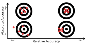
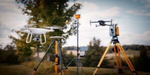
Completing surveys with drones is not as easy as taking a few shots from the sky. In order to get the most accurate data, you will need a drone that is equipped with high-precision sensors and cameras.
Surveying in Australia is one of the most common applications for drones. With its large landmass and varied terrain, Australia is the perfect place to put drones to work. Ensure the drone service provider you engage is competent in creating high quality accurate maps and digital terrain models.
If you’re looking for a drone that can handle all of your surveying and mapping, the below outlines a list of very capable drones currently available on the market for aerial surveying.
When choosing a drone for surveying or mapping, there are several factors you need to consider, such as accuracy, range, flight time, and payload capacity. We’ve compiled a list of the top drones for surveyors and GIS professionals, so you can find the perfect one.
DJI Mavic Series
The DJI Mavic series is another popular option for surveyors and GIS. Depending on which model you choose, the Mavic series can be equipped with a range of different cameras. It also features a three-axis gimbal that stabilises the camera and prevents image blur.
The Mavic series is able to fly for up to 27 minutes on a single charge, making it ideal to most small to medium surveys.
The Mavic 2 is the most popular of the series even more than the Mavic 3 as it is compatible with automated flight software that allows the operator to fly specific flight paths to capture optimal image overlap and cover areas efficiently.
The Mavic 3 is great if you are completing a 3D scan of a strucutre of area and are able to fly it manually without flight planning software. A good example might be a mobile tower, bridge or building facade.
The main drawbacks of the Mavic series are that it does not have a global shutter which can introduce rolling shutter artifacts in images, and that it is not as rugged as some of the other options on this list. It also does not have RTK or PPK capabilities. Well it does actually but only for positioning accuracy and does not assist in creating accurate maps and models.
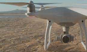
DJI Phantom Series
The DJI Phantom series is one of the most popular options for surveyors and GIS professionals. Using a global shutter and a 20 megapixel camera, the Phantom series is able to capture high-quality images and videos. In addition, the Phantom series comes with a variety of features that make it easy to fly and map with, such as GPS positioning and an intelligent flight control system.
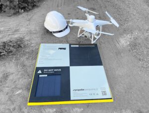
The Phantom 4-RTK is the newest addition to the Phantom series and is specifically designed for surveying and mapping. It features a built-in GNSS receiver that provides real-time centimeter-level positioning data. This in combination with a base stattion and ground control points (GCPs) allows you to create highly accurate maps.
If you are looking for a drone that is specifically designed for surveying and mapping, then the DJI Phantom series is a great option.
Yuneec H520
The Yuneec H520 is a hexacopter that was specifically designed for surveying and mapping. It features a six-rotor design that makes it more stable in the air and able to carry a heavier payload.
The Yuneec H520 comes equipped with a 20 megapixel camera and a three-axis gimbal. It also has a variety of sensors that make it easy to fly and map with, including GPS, ultrasonic, optical flow, and barometric pressure sensors.
One of the main advantages of the Yuneec H520 is that it is compatible with a wide range of software, including Pixhawk, ArduPilot, and Dronecode. This makes it easy to integrate into your existing workflow.
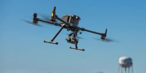
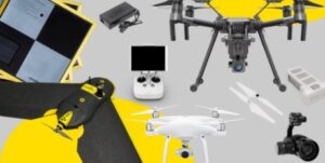
M300 + P1
The M300 + P is a great option for surveyors and GIS professionals who are looking for a drone that is specifically designed for surveying and mapping and our go to for most jobs. It features a built-in GNSS receiver that provides real-time centimeter-level positioning data with RTK or PPK corrections. The 45mp camera with global shutter allows crystal clear images with high resolution for deadly accurate surveys. The smart oblique capture is also very useful for time efficient 3D scans. While there are too many features to list here we can confidently recommend the M300 + P1 as the best option for areas under 1,000ha.
Wingtra One
The Wingtra One is a fixed-wing drone that was specifically designed for surveying and mapping. It features a long flight time (up to 80 minutes on a single charge) and the ability to cover large areas quickly and efficiently. It is equipped with a 20 megapixel camera and a three-axis gimbal. It also has a variety of sensors that make it easy to fly and map with, including GPS, ultrasonic, optical flow, and barometric pressure sensors.
One of the main advantages of the Wingtra One is that it can take off vertically unlike other fixed wing drones. Therefore it can launch almost anywhere and stay in the air for much longer than multi rotor drones.
The Mavic series from DJI is a great option for surveyors and GIS professionals. The Mavic Pro is a small, lightweight drone that is easy to transport and can be flown in
There you have it! These are the top five drones for surveyors and GIS.
Reach out to High Exposure if you have any questions in regards to your surveying projects