What are GCPs?
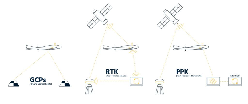
A GCP, or a Ground Control Point, allows surveyors to gather data by defining known points on the earth’s surface and using those points to geo-reference aerial imagery. Historically, surveyors would walk around the job site with a GPS receiver capturing hundreds or thousands of points to create an accurate grid.

Once surveyors convert this grid into a surface, they can coordinate estimations of stockpile volumes, track cut/fill during earthworks, and generally track progress during construction. With the introduction of drone data, high-accuracy surveys can be completed in as little as 20 minutes.
Many surveyors still use GCPs to accurately position their maps and models to their known reference points. They may even use these reference points as checkpoints to measure map accuracy.
What is RTK?
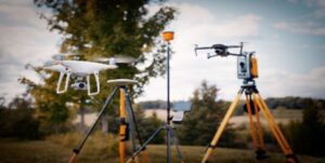
RTK, or Real-Time Kinematic, is a GPS correction technique that provides real time corrections to location data while the drone is capturing imagery. With the DJI Phantom 4 RTK, or the Mavic 3 Enterprise RTK, or any other RTK enabled drone, it’s now possible to capture desired accuracy data without using as many GCPs during surveying.
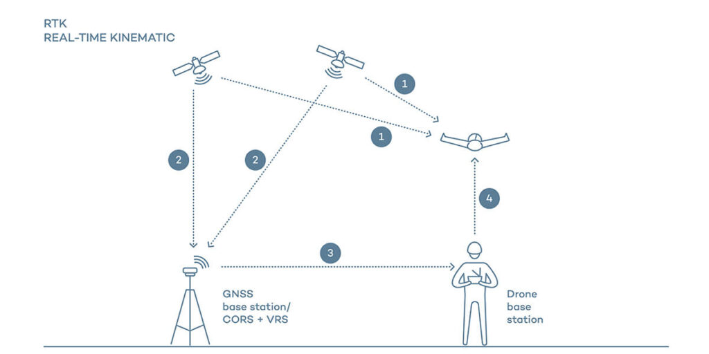
RTK can enhance the precision of positional data from satellite-based positioning systems. RTK relies on a single reference station (or a network of stations such as a AUSCORS Network) to deliver correction data for geotags during flight. This means we not only use the GPS data from the drone, but the positional information from a nearby reference station to accurately pinpoint the location of the drone. Note, this gives us an accurate position of the drone, but doesn’t give us specific information about any point on the ground. We still recommend using GCPs in conjunction with an RTK drone to get the best map accuracy.
The DJI Mavic 3 Enterprise is one of the few drones that allows surveyors to capture high-accuracy data, without the need to place as many, or any, GCPs.
The main advantages of using an RTK drone are pretty obvious. It allows for on-demand surveys at a fraction of the time, increases map survey accuracy, and enables surveyors to capture high accuracy data more frequently.
The major drawbacks?
Aerial-based RTK technology is still a relatively new concept. It requires a base station or a subscription to a network in order to operate, and it requires a clear field of view to capture accurate data.
An RTK drone works best in a relatively open area with minimal trees, buildings, and other obstacles to maintain a strong connection to the base station. If the drone loses connection, you may obtain inaccurate data.
That’s where PPK comes in…
What is PPK?
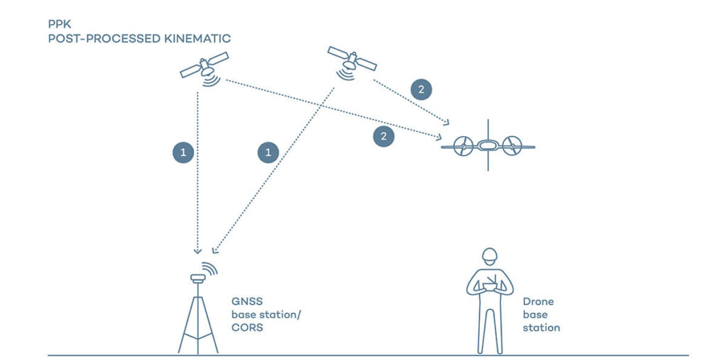
Post Processed Kinematic (PPK) is another GPS correction technology, similar to RTK, that works to correct geotagged located data. The main difference is that location data is updated after the drone has captured images, thus being “post-processed.”
The primary benefit of using this form of capturing is the increase in PPK vs RTK accuracy. You can use the Phantom 4 RTK or Mavic 3 Enterprise RTK to capture PPK data as well. The base station is easy to set up, and you have more flexibility in where you capture data.
The main advantage to using PPK drones is that you can fly in a crowded environment without a visual line of sight– like a city center – and still capture high-precision data or conduct longer flights over varied terrain, all while knowing you won’t lose connection resulting in inaccurate data. We still recommend using a few GCPs with PPK data to increase your map accuracy. Be sure to use checkpoints as well to validate overall accuracy once the map is processed.
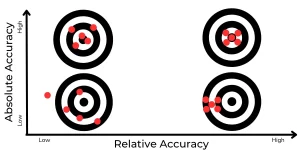
GCP vs RTK vs PPK
Ultimately, it’s up to you as the user to determine the best option for your survey. If it’s a small area, using GCPs will help you capture high-accuracy data in the shortest time possible (without the added expense of purchasing an RTK or PPK platform).
If you’re mapping a large, wide open area that’s often changing, consider capturing RTK drones vs GCP imagery. Or, if you’re flying in close quarters, in a crowded environment, or conducting a long-duration flight, consider the stronger signal strength from capturing PPK imagery. If you’re looking for the best absolute accuracy, consider combining PPK images with GCPs on your site.