The Rydges Hotel was planning on adding some structural changes to the building. There were no current plans to utilise for the design and therefore needed to be created.
This case study outlines the steps taken, challenges faced, and the successful outcome of this intricate drone surveying project.

Objective:
High Exposure was engaged to assist in creating a survey accurate point cloud using the coordinate reference system GDA 2020 & AHD. The primary goal was to generate a high-resolution 3D model of Rydges Hotel using an RTK (Real-Time Kinematic) drone equipped with advanced mapping capabilities. Achieving survey-grade accuracy was essential for future architectural assessments, renovations, and promotional materials.
Methodology:
Preparation:
-
- Conducted thorough research on the site and local regulations and best time of day to complete the survey.
- Acquired necessary approvals from the council, highlighting the project’s purpose and adherence to safety and privacy regulations. Coordination with the ferry terminal was planned and local businesses were notified
- Traffic control was organised to assist with ensuring a safe survey and as part of council and CASA regulations.
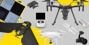
RTK Drone and Survey Equipment:
-
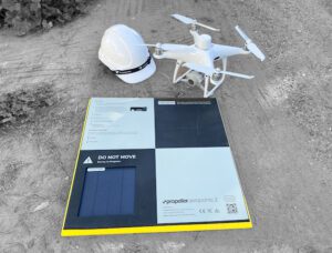
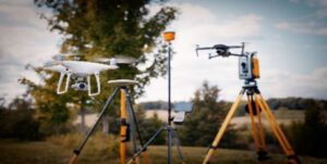
- A base station and RTK drone was used for precise georeferencing and accurate positioning that was capable of producing high resolution imagery.
- Utilised ground control points (GCPs) strategically placed around the hotel to enhance survey accuracy.

Authorisation Process:
Council & CASA Regulations
-
- Initiated communication with the local council to obtain necessary permits for the aerial survey.
- Submitted a comprehensive project plan, emphasising safety measures, data privacy, and adherence to CASA (Civil Aviation Safety Authority) regulations.
Traffic Control Measures:
-
- Collaborated with local council to implement traffic control measures in the vicinity of the hotel.
- Coordinated with traffic management teams to mitigate the impact on vehicles and pedestrians during drone operations.
Execution:
Flight Planning:
-
- Employed advanced flight planning software to design optimal flight paths, ensuring complete coverage of the hotel from multiple angles. Image overlap and ground sample distance was calculated and inputted into the plan
- Factored in safety buffers and altitudes to accommodate traffic control requirements.
- A combination of automated and manual flight techniques were used in which the photogrammetry mission was successfully completed
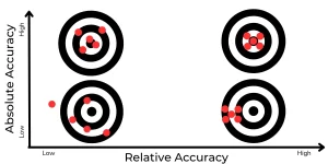
Survey Accuracy:
-
- Leveraged RTK technology to achieve a high accuracy drone survey, crucial for creating a precise 3D point cloud. Absolute accuracy of 20-30mm was achieved throughout the point cloud and processed in GDA 2020 and AHD
Ground Control Points:
-
- Established and surveyed ground control points using GPS receivers, enhancing the accuracy of the mapping data.
- Strategically placed GCPs around the hotel’s perimeter and critical features.
Data Collection:
-
- Executed multiple drone flights, capturing high-resolution imagery to generate the 3D point cloud.
- Ensured data integrity by cross-verifying RTK data with ground control points during and after each flight.
Deliverables
-
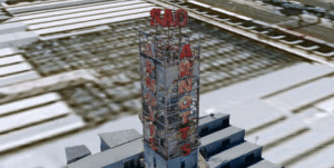
- Successfully generated a detailed and survey accurate 3D point cloud of The Rydges Hotel, providing a comprehensive representation of its structure and surroundings.
- A life like 3D mesh model was also created and provided to the client which greatly assisted their planning phase.
- The model was delivered as an e57 file and was able to be uploaded in Revit, AutoCAD and other GIS suites.
- An online 3D model of the building was also provided seen in the link below
Conclusion:
The successful completion of the Rydges Sydney 3D mapping project demonstrates the effectiveness of careful planning, advanced technology utilisation, and a commitment to regulatory compliance. The accurate and detailed 3D model serves as a valuable asset for future architectural assessments and promotional materials while setting a benchmark for responsible and precision-centric drone mapping operations in urban environments.