
RTK Vs PPK Drone Data
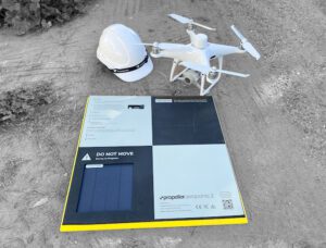
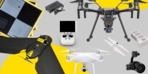
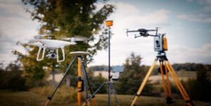
We have a new drone…. An RTK/PPK drone to be precise.
I thought it would be a good opportunity to explain why this is a very good thing. So, which is better RTK or PPK? The very annoying answer is….it depends.
In short, the benefits are;
- Very accurate maps and 3D models (RTK & PPK)
- Centimetre level positioning accuracy (RTK)
- Resistance to interference (RTK)
- Improved signal in built up urban areas (RTK)
When using a Non-RTK drone, the onboard GPS receiver gets it location data directly from satellites. Therefore, because this data is being calculated by several distance measurements you can see an inaccuracy up to several meters.

So what is RTK? It stands for Real Time Kinematic. It means that the drone can achieve real time GPS corrections to enable cm level positioning of the drone itself and also of the image location meta data. DJI drones use a combination of GPS & GLONASS with a ground station to achieve these accuracies. It also requires a 4G or WiFi connection to connect the drone to a base station or virtual reference station. The major drawback is that if there is a break in the signal then the RTK corrections are not possible. More about the downfalls of RTK here.
Enter PPK! Post Processing Kinematic is (kind of) what it sounds like. GPS corrections are processed in the image metadata after the flight as opposed to during with RTK. The data is logged within the aircraft and then combined with the base (base station, ground control points or cors data) to achieve high accuracy. This is the most reliable option for highly accurate maps due to not requiring a 4G signal. The drawbacks here are there is more work to do in post to achieve these accuracies. Also there is no high accuracy positioning or benefit of resistance to interference and low GPS signal.
Clear as mud? Ok, lets go into more detail about the benefits listed earlier.
Very accurate maps and 3D models (RTK & PPK)
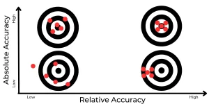
The first thing to note is that you don’t actually need an RTK/PPK enabled drone to achieve accurate maps & models, but it bloody well helps! While we do recommend to still use ground control points and check points with an RTK or PPK enabled drone, you won’t need even close to as many. This reduces room for error so it is much more reliable. Also, you save heaps and heaps of time laying, recording, collecting ground control. Huge win! With favourable conditions you can expect about 2-3cm accuracy on the X & Y axis and 3-5cm on the Z axis. While both RTK & PPK will provide the means to create highly accurate maps, PPK is preferred due to the reliability of positional accuracy from not needing to rely on a constant connection.
Centimetre level positioning accuracy (RTK)
This is particularly useful when operating in tight spaces or during windy conditions as the drones pinpoint positioning will introduce a safer working environment due to being less likely to drift into an object. It is also more likely to capture higher quality data due to minimal shaking and movement even in high winds. This becomes more apparent with close visual inspections. When you have a small field of view in the camera frame, any movement is exaggerated. RTK positioning accuracy makes it easier and much less time consuming to get blur free footage of the exact area you are trying to inspect.
Resistance to interference (RTK)
Operating in areas with high interference can cause the drone to ‘fly away’. That’s just not good for anyone involved. This might be due to areas with high RF (radio frequency) like urban locations with a high volume of WiFi signals. EMI (electromagnetic interference) is also another cause which comes from high voltage powerlines, radio or telco towers and large metallic structures. Therefore, RTK provides a safe working environment in these areas allowing the operator to capture the necessary data without having to make compromises.
Improved signal in built up urban areas (RTK)
Operating in a city environment with tall buildings can result in GPS signal being poor or inaccurate. This can result in an erratic drone, which is by far my least favourite type of drone. Using RTK corrections to increase GPS accuracy ensures the drone stays in the air in the position you intended providing a much safer working environment.
So there you have it. A crash course in RTK & PPK drones.
Contact High Exposure if you are looking to improve the way you conduct asset inspections.

One Comment
When you have a small field of view in the camera frame, any movement is exaggerated.