High Exposure, a leading provider of aerial surveying and photogrammetry solutions, was contracted to undertake a comprehensive survey of the Old Newcastle Station. The council intended to utilise the survey data for designing proposed additions to the site, requiring detailed external and internal point clouds of the historic structure.
Objective:
The primary objective of the project was to create high-resolution aerial photogrammetry 3D models and terrestrial scans of the Old Newcastle Station. These models would serve as a basis for the council’s design process. Specifically, the goals were:
- Generate detailed external and internal models of the Old Newcastle Station.
- Utilise aerial and terrestrial scanning techniques to ensure comprehensive coverage and high detail.
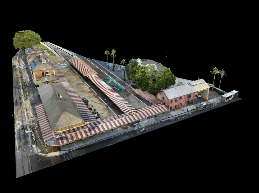
- Produce a fully merged point cloud for integration into GIS software, such as Revit.
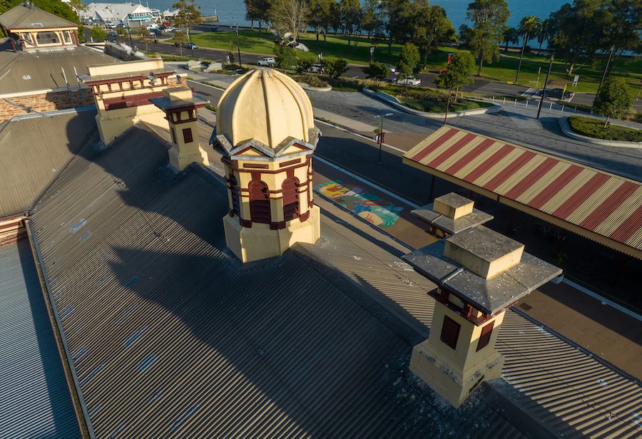
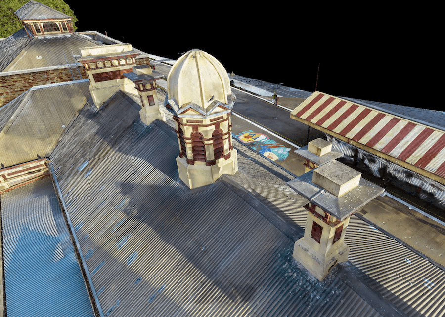
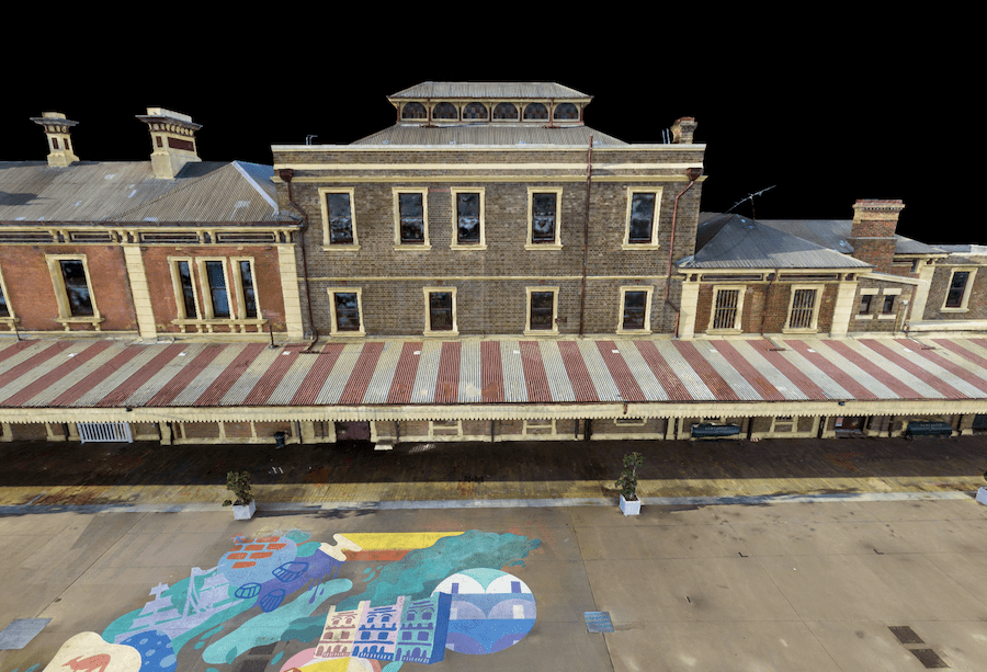
- Create a high-resolution aerial digital twin for inspecting the roof and facades of the buildings.
Methodology:
To achieve the project objectives, High Exposure employed a combination of aerial and terrestrial scanning techniques. The process involved the following steps:
Aerial Survey with Ground Control and RTK Drone: A drone equipped with Real-Time Kinematic (RTK) technology for precise positioning. Ground control points were strategically placed to enhance the accuracy of the aerial survey. This ensured that the aerial photogrammetry data captured the external features of the Old Newcastle Station with high precision. These points were also used to align the terrestrial scans with the aerial data.
Terrestrial Scan with BLK 360: The team conducted terrestrial scanning using a Leica BLK360 laser scanner. This device facilitated the capture of detailed data from both the external surroundings and internal rooms of the station. The terrestrial scan covered areas that were inaccessible or challenging to capture via aerial survey, such as intricate architectural details and confined spaces.
Photogrammetry Capture Technique: A thoroughly developed photogrammetry & scanning method was implemented during both aerial and terrestrial scanning to ensure comprehensive coverage and high detail. By capturing multiple overlapping images from different angles, the team could reconstruct an accurate 3D model of the Old Newcastle Station.
Data Processing: The aerial and terrestrial scans were processed and merged to create a unified point cloud dataset. This fusion of data ensured seamless integration and comprehensive coverage of the entire site.
Deliverables:
Two main components to the Newcastle Council were prepared:
- Fully Merged Aerial and Terrestrial Point Cloud: The merged point cloud dataset, accurately representing both external and internal features of the Old Newcastle Station, was provided for integration into GIS suites like Revit. This comprehensive dataset served as a valuable resource for the council’s design and planning processes.
- High-Resolution Aerial Digital Twin: Additionally, a high-resolution aerial digital twin was created specifically for inspecting the roof and facades of the buildings. This digital twin offered detailed visualizations of the structure, enabling precise examination and analysis.
Conclusion:
The project achieved a remarkable absolute accuracy of 25-30mm using GDA2020 AHD, meeting the stringent requirements of the Newcastle Council. The detailed aerial and terrestrial models provided invaluable insights into the Old Newcastle Station, aiding the council in the design and planning of proposed site additions. High Exposures expertise in drone surveying and photogrammetry played a crucial role in delivering accurate and comprehensive data for this historic preservation project.
By leveraging advanced surveying technologies and techniques, High Exposure Company contributed to the preservation and enhancement of Newcastle’s cultural heritage while supporting the council’s urban development initiatives.
Please reach out to High Exposure to discuss your next building survey project