Aerial Surveys for Contour & Mapping
Using drones to create contour surveys play a fundamental role in ensuring informed decision-making, efficient project planning, and the sustainable development of land. They provide a foundational understanding of the landscape, guiding various aspects of design, construction, and environmental management.
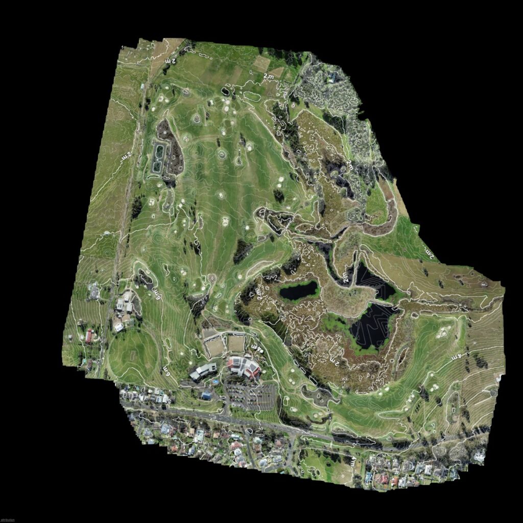
A contour survey, also known as a topographic survey or contour map, is a type of land survey that involves mapping the elevation of the land’s surface at regular intervals. The primary purpose of a contour survey is to represent the three-dimensional characteristics of the terrain, showing how the land slopes and changes in elevation across a specific area.
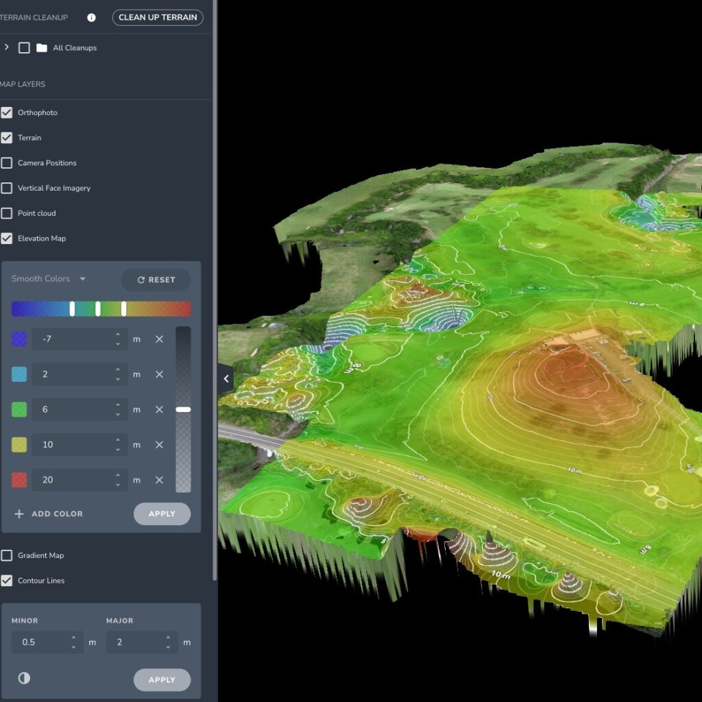
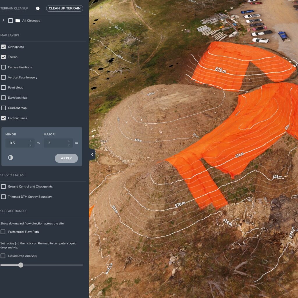
Contour surveys provide detailed information about the elevation of the land at various points. This data is presented in the form of contour lines, which connect points of equal elevation. These contour lines are imaginary lines drawn on a map to represent points of equal elevation above a reference datum, usually AHD. Each contour line indicates a constant elevation, and the spacing between lines reflects the slope of the land.

Use Cases & Deliverables for Aerial Contour Surveys
Using drones for contour surveys are useful for various purposes in land development, construction, environmental planning, and other fields. Accurate and detailed contours can be captured and processed to analyse changes in elevation across a given area.
- The file format is delivered in DWG or DXF to enable compatibility with AutoCAD as well as other GIS & BIM software. Other formats such as PDF are available upon request.
- Contours at up to 0.2m intervals can be generated with contour ‘smoothing’ also available if required.
- GDA2020 & AHD are the reference systems utilises for all our surveys.
Here are some key reasons why drone contour surveys are valuable.
Topographic Mapping:
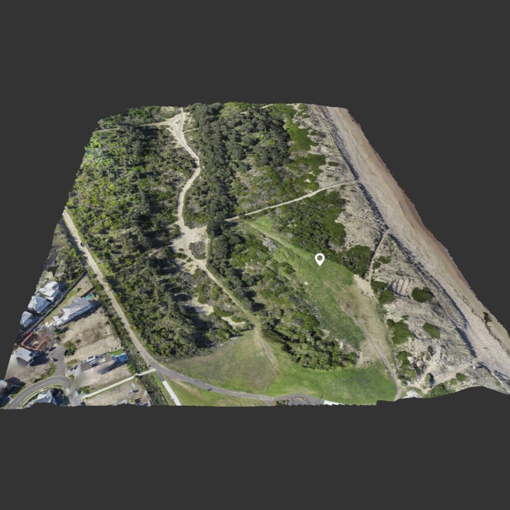
Contour surveys provide accurate topographic maps that represent changes in elevation across a landscape. These maps offer a comprehensive view of the terrain, including hills, valleys, and slopes. Commonly used for sand dune and gold course surveys.
Land Development and Planning:
For architects, engineers, and urban planners, contour surveys are essential in understanding the existing topography of a site. They help identify suitable locations for buildings, roads, utilities, and other infrastructure projects.
Drainage and Grading Analysis:
Contour maps assist in analyzing the natural drainage patterns of a site. This information is crucial for designing effective drainage systems, preventing waterlogging, and avoiding potential flooding issues.
Erosion Control and Land Stability:
By studying contour lines, professionals can assess the stability of the land and identify areas prone to erosion. This information is critical for implementing erosion control measures and ensuring the long-term stability of the site.
Cut and Fill Calculations:
Contour surveys enable accurate calculations of cut and fill volumes during construction projects. This information is vital for earthwork planning, helping to optimize excavation and fill operations while minimizing costs.
Slope Analysis:
Contour maps provide insights into the slope of the land. This information is valuable for determining suitable building locations, planning road alignments, and assessing the feasibility of construction on hilly terrain.
Visual Representation:
Contour maps offer a visual representation of the landscape, making it easier for stakeholders to understand the site’s topography. This visual tool aids communication among project teams, clients, and regulatory authorities.
Environmental Impact Assessment:
In environmental studies, contour surveys help assess how changes in the landscape, such as construction activities, may impact the surrounding environment. This information is crucial for minimizing ecological disruptions.
Site Grading and Design:
Engineers use contour surveys to design site grading plans that optimize the distribution of soil to achieve the desired slopes and contours. This is important for both aesthetics and functionality.
Infrastructure Planning:
Contour surveys support the planning of infrastructure projects such as roads, bridges, and utilities. They provide essential information for designing structures that are compatible with the natural topography.
Floodplain Mapping:
By understanding the elevation changes in a landscape, contour surveys contribute to accurate floodplain mapping. This information is critical for assessing flood risks and developing effective flood control measures.
Regulatory Compliance:
Contour surveys may be required by local authorities as part of the regulatory approval process for construction projects. Compliance with these requirements ensures that projects adhere to zoning and environmental regulations.
Real Estate Development:
Developers use contour surveys to evaluate the suitability of land for residential or commercial projects. Understanding the topography is crucial for creating attractive and functional developments.
Image Gallery

Traditional Surveys Vs Drone Surveys
Advantages of employing Drone LiDAR & Photogrammetry Surveying:
Efficiency: Drones outfitted with LIDAR sensors enable swift coverage of expansive areas, thereby diminishing the time and resources necessary for surveying.
Safety: Drones can navigate and survey challenging or perilous terrains, like steep slopes or remote locales, which may pose risks to human surveyors.
Cost-effectiveness: Operating drones is more economical than utilizing traditional ground-based equipment, presenting an economically viable alternative for aerial surveying.
High Precision: LIDAR-equipped drones are capable of capturing intricate, high-resolution data, supplying detailed information for diverse applications, including the creation of digital elevation models and digital surface models.
Foliage and Cloud Penetration: LIDAR sensors on drones can capture data through foliage and clouds, facilitating the surveying and mapping of extensive areas such as forests, mines, and coastal regions.
Limitations of Conventional Surveying:
Time-intensive: Traditional surveying methods tend to be time-consuming, particularly when covering large areas.
Safety Concerns: Traditional surveying methods may pose safety risks, especially in remote or hazardous regions.
Cost Considerations: Traditional surveying methods can incur high costs, particularly for extensive survey coverage.
Aerial contour surveys hold the potential to significantly enhance efficiency and precision while concurrently reducing expenses. Drones expedite the data collection and processing phases, accelerating project completion and bolstering overall productivity. Additionally, the advanced capabilities of drones, including high-resolution cameras and precise sensors, contribute to improved survey result accuracy.
Furthermore, the incorporation of drones minimises the necessity for repeated site visits and enables access to challenging or hazardous locations, such as steep terrains or unsafe sites. Drones are adaptable to various environmental conditions, including adverse weather or nighttime scenarios. By embracing drone technology, traditional land surveyors can maintain competitiveness and deliver superior services to their clientele.